We are taking a rest day among the other RVs seeking refuge from the rain. Yesterday it rained from 11am until early this morning sometime after 6am highs in the low 50s. When we pulled in to Glacier Campground yesterday, soaking wet and chilled we were welcomed into this wonderful old lodge with a huge fireplace, beautifully handcrafted wooden chairs, a t.v. and walls full of books, games and VHS tapes. The room was filled with laughter coming from a group of kids playing chess on the floor. Luckily they still had tent sites available and we were instructed to head across the lawn and could camp anywhere on the lawn next to the playground. We found an awning that in one point in time looked as if they might of had picnic tables underneath it, but on this day there was a rotting boat underneath leaving just enough room for us to pitch our tent. We quickly set it up, threw in our gear and headed back to the warm lodge. Everything about the lodge seemed familiar. The crackling fire, me hanging my shoes, socks and jacket above and in front of it to dry. The kids voices fighting over the chess pieces, the smell, the decor of comfort clutter. It reminded me of camp-outs and holiday times spent with family. It was the immediate warmth that began to stir the memories and remind me that I was exactly where I needed to be. My yearning for stillness and kind company and the ability to sink into a cozy couch with the camp dog asleep next to me was fulfilled. I fell asleep to the sounds of a college basketball game playing on the t.v.
******
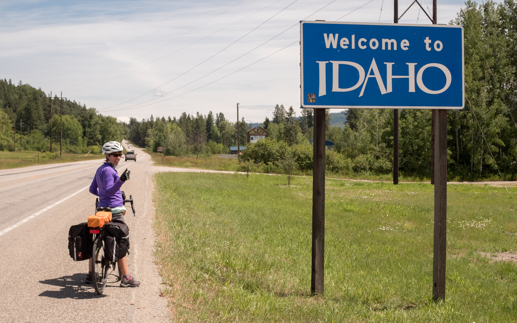
Over the past few weeks I have had an internal conflict of whether to go “the going to the sun road” over the highest peak of Logan’s Pass that sits at 6600 feet or to take “Maria’s route” with passes around 5200 feet that sends us through East Glacier and through the Blackfeet Indian Reservation. I gave myself some ultimatums, like when we get to West Glacier, if my knee is still in bad shape, then Maria’s route will be the choice, because there will be no way I will be able to make the climb without compromising the following weeks. But now that we’re here and my knee seems to be doing better, I still am quite hesitant to do it. Matt and I have gone over different options and have talked about the pros and cons of each route. At this point, given the last two days in West Glacier, the high amounts of traffic, RV traffic especially and the lack of shoulders have given weight to our decision. There also is a real chance that I could freak out on the descent and ruin the trip for passengers in the line of cars behind me. To them, they would be witnessing a girl on her bike, gripping for dear life, while riding her brakes in the middle of the lane and loudly chanting some weird mantra, while only going 7 miles an hour. I figure this might not be the best representation for the biking community. Also, a local newspaper reported that May 2016 was the busiest month of May on Record for Glacier National Park according to government statistics. This was even before they opened ‘the sun road”. Overall, visitation is up 18% and continues to climb, which we witnessed yesterday, as we headed into the park, waiting in a car line of about 20 in the pouring rain with news that they were expecting a few inches of snow up on Logan’s pass. People are flocking to this place. For Matt and I, this figure means lots of people, too many vehicles, limited wildlife, and unsafe roads. Being one of the crown jewels of North America and being the National Park Service’s Centennial, we are going to opt for taking Maria’s Route. However, we do hope to get up to Logan’s pass, perhaps by one of the iconic Red Tour buses. These buses started taking visitors up the Sun Road back in 1936. Out of the original fleet of 35 that was given to Glacier National Park, 33 are still in use. These model 706’s, for three months, carry thousands of visitors over the roller coaster routes of the National Park and then rest the other six months near Columbia Falls. These beautiful shiny vessels equipped with the wear and tear of endless climbs mirror the weathered strength I feel within. Perhaps after 3000 more miles we too will look like those antique Red Tour buses, red and shiny with the glow and dust of distance and experience. (Stats and info cited from FlatheadBeacon.com)
*********
Also, today I taught a group of kids how to play rummy, palace and garbage at the campsite. I got schooled on all fronts. I dedicate my obsession for playing cards and games to my family, friends and to all the kids/coworkers at Ocean Palms Elementary who tolerated my need to fill the afternoon with endless rounds of card and board games.
 a city wide bike ride for Autism. We decided to get a hotel room and couldn’t check in until 2pm. It was only 11am, so we decided to use their hot tub to soak my knee and walk around the town. Now I know this does not quite seem like roughing it, chilling in a hot tub, but I can’t tell you how much it helped my knee. The hours ticked by and soon it was time to retreat into the room, with a pizza and a local bottle of cabernet. Some how, the rain knew just when to open up and begin to pour, right as I lay in bed, ice on my knee and Dances with Wolves on the tv.
![IMG_0042[1]](https://crossingacontinent.com/wp-content/uploads/2026/04/IMG_00421.jpg)
![IMG_0030[1]](https://crossingacontinent.com/wp-content/uploads/2026/04/IMG_00301.jpg) herman Pass. The last three days have been a whirling of miles, small towns and cute resting spots. In Tonasket, the vistor center offers a patch of grass behind it for bikers headed through. We spent the evening visiting their local co-op treating ourselves to a bottle of their local hard blueberry cider shared over a radio-story from This American Life. We camped right across from a yoga studio, but being Sunday it was closed. Monday started right off the bat with a tough climb up the Wauconda Pass (4310′), preparing ourselves and my knee for next day to come. We peaked and descended and were surprised when the trail told us to hang a left onto a paved bicycle path that took us high above state road 20. It weaved in and out and around the mountain side. It was a nice enclosed ride closing out our day. That evening we set up camp outside Republic at their fair grounds. Free Ranged goats came up to us and sniffed at our gear. I had just resupplied and had a kale/spinach bag that i let them nibble at. They reminded me of my days spent with the goats at the Brevard Zoo’s Petting Zone. We also reunited with Dan and Lise and their tribe who are cycling for victims of strokes. They are pulling a travel trailer and our biking each day while a support crew brings the trailer to meet them along the way and at night. They are headed East as well but will finish in Boston. They are looking for a driver to help with the trailer over the next two months, so if you or you know of someone wanting to help check out Spokesfightingstrokes.org. We went to bed early and and parted with our new friends early the next morning to fight the 15 mile climb to our highest point on the Northern Tier, Sherman Pass. My knee ached the entire way and I had taken my recommended dose of Advil for the whole day by 11am. Two hours later we reached the top, took a break and clipped in for the final 20 mile steep descent. As long as I can just glide and not have to use my knee, I can get off the mountain. The wind had started wipping up, and the temp dropped, so we put on all our layers for the downhill. Face covered with a buff, the thrilling downhill had finally brought joy and pain relief. I had finally perfected my downhill and the fear was now replaced with joyful speed. We stopped 12 miles down at a spot where the CCC had built an American Camp during the Great Depression. A small pebbled creek runs along side a small meadow of wildflowers. The only building that remains is a small bath house and historical signs describing the area. With the sun shining down on the creek we took a long break, ate a snack and I soaked my knee. The pain was immediately gone as I rested it in the water. Had it not been in the low 60’s I would have gone for a full body submersion, but the air was too cold. As the clouds moved in, we left that special spot and completed the downhill across the Columbia River and into Kettle Falls campground. The east side of Sherman Pass was by far the prettiest part of the trip thus far. It followed a creek the whole way up with lots of waterfalls and dammed ponds.
herman Pass. The last three days have been a whirling of miles, small towns and cute resting spots. In Tonasket, the vistor center offers a patch of grass behind it for bikers headed through. We spent the evening visiting their local co-op treating ourselves to a bottle of their local hard blueberry cider shared over a radio-story from This American Life. We camped right across from a yoga studio, but being Sunday it was closed. Monday started right off the bat with a tough climb up the Wauconda Pass (4310′), preparing ourselves and my knee for next day to come. We peaked and descended and were surprised when the trail told us to hang a left onto a paved bicycle path that took us high above state road 20. It weaved in and out and around the mountain side. It was a nice enclosed ride closing out our day. That evening we set up camp outside Republic at their fair grounds. Free Ranged goats came up to us and sniffed at our gear. I had just resupplied and had a kale/spinach bag that i let them nibble at. They reminded me of my days spent with the goats at the Brevard Zoo’s Petting Zone. We also reunited with Dan and Lise and their tribe who are cycling for victims of strokes. They are pulling a travel trailer and our biking each day while a support crew brings the trailer to meet them along the way and at night. They are headed East as well but will finish in Boston. They are looking for a driver to help with the trailer over the next two months, so if you or you know of someone wanting to help check out Spokesfightingstrokes.org. We went to bed early and and parted with our new friends early the next morning to fight the 15 mile climb to our highest point on the Northern Tier, Sherman Pass. My knee ached the entire way and I had taken my recommended dose of Advil for the whole day by 11am. Two hours later we reached the top, took a break and clipped in for the final 20 mile steep descent. As long as I can just glide and not have to use my knee, I can get off the mountain. The wind had started wipping up, and the temp dropped, so we put on all our layers for the downhill. Face covered with a buff, the thrilling downhill had finally brought joy and pain relief. I had finally perfected my downhill and the fear was now replaced with joyful speed. We stopped 12 miles down at a spot where the CCC had built an American Camp during the Great Depression. A small pebbled creek runs along side a small meadow of wildflowers. The only building that remains is a small bath house and historical signs describing the area. With the sun shining down on the creek we took a long break, ate a snack and I soaked my knee. The pain was immediately gone as I rested it in the water. Had it not been in the low 60’s I would have gone for a full body submersion, but the air was too cold. As the clouds moved in, we left that special spot and completed the downhill across the Columbia River and into Kettle Falls campground. The east side of Sherman Pass was by far the prettiest part of the trip thus far. It followed a creek the whole way up with lots of waterfalls and dammed ponds. over our second pass (Loup Loup Pass at elevation 4020) I am confident that the only way I was able to make it up these beautiful passes is because of my granny gear. Traveling a tiny it faster than walking speed, I’m at my lowest gear cranking the crap out of the petals. This sweet, wonderful Granny Gear lets me spend 4 hours of climbing to cover 12 miles. Without this gear, these passes would not be possible.
 was barely able to cycle it through each stroke. We headed towards a store to get a knee brace and some ice. After icing it for 30 minutes in the parking lot, we decided our day would have to end here in Omak. We are taking a zero day tomorrow due to wind and 80% chance of rain, so this will allow my knee plenty of rest before our next two climbs.